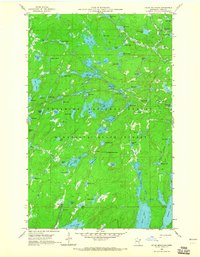
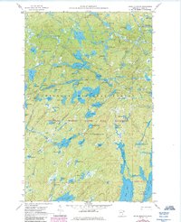
1960 Map of Kelso Mountain
USGS Topo · Published 1965About this map
Kelso Mountain rises as a central landmark in this dense lake-strewn landscape within the Superior National Forest. This 1960 field-checked survey reveals an intricate network of waterways and glaciated terrain before modern recreation pressures reshaped northern Minnesota's wilderness access. A solitary Lookout Tower stands near the mountain summit, serving as a critical point for fire surveillance over the surrounding Minnesota State Forest. The map documents a complex hydrology where lakes like Mesaba Lake, Hub Lake, and Florence Lake are linked by small streams and portages. The sheer density of named water bodies, from Myth Lake in the northeast to Wawaswi Lake in the west, illustrates the character of a region where travel was defined by the water and the topography of the Iron Range. For researchers, this document preserves the precise names and positions of remote features such as Bologna Lake and Poe Lake during a period of active resource management.
Find a feature on this map
77 named features on this map. Tap any name to fly to it.
Don’t see what you’re looking for? This feature index may not catch every label — zoom into the map to look around manually.
Map Details
Editions of this 1960 Kelso Mountain Map
5 editions found
Other maps of this area

1954 · Two Harbors
USGS Topo · 1:250,000

1957 · Two Harbors
USGS Topo · 1:250,000

1957 · Quetico
USGS Topo · 1:250,000

1958 · Two Harbors
USGS Topo · 1:250,000

1959 · Ogishkemuncie Lake
USGS Topo · 1:24,000

1959 · Gillis Lake
USGS Topo · 1:24,000

1960 · Lake Polly
USGS Topo · 1:24,000

1960 · Kawishiwi Lake
USGS Topo · 1:24,000

1960 · Sawbill Camp
USGS Topo · 1:24,000

1960 · Beth Lake
USGS Topo · 1:24,000