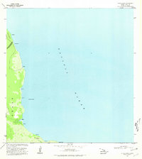
1980 Map of Keaau Ranch
USGS Topo · Published 1981About this map
Keaau Ranch and the rugged Puna coastline dominate this 1980 survey of the island's eastern shore. The map follows the thin strip of coastal vegetation and habitation between the lava-carved terrain and the Pacific Ocean. Small settlements and named landmarks like Anapuka, Papai, and Haena dot the shoreline, connected by limited infrastructure such as a Jeep Trail that skirts the southern reaches toward Keauhou. This era represents a period of transition for the region, where traditional coastal place names like Wahine Maka Nui and Paukupahu persist alongside agricultural ranching interests. The boundary between the South Hilo District and Puna District cuts across the northern end of the map, illustrating the administrative divisions governing this sparsely populated volcanic landscape. From the jutting profile of Kaloli Point to the sheltered Paki Bay, the map provides a precise record of the shoreline's edge.
Find a feature on this map
18 named features on this map. Tap any name to fly to it.
Don’t see what you’re looking for? This feature index may not catch every label — zoom into the map to look around manually.
Map Details
Editions of this 1980 Keaau Ranch Map
This is the sole edition of this map. No revisions or reprints were ever made.
Other maps of this area

1915 · Honomu
USGS Topo · 1:62,500

1917 · Hilo
USGS Topo · 1:62,500

1924 · Makuu
USGS Topo · 1:62,500

1932 · Hilo
USGS Topo · 1:62,500

1954 · Hawaii North
USGS Topo · 1:250,000

1959 · Hawaii North
USGS Topo · 1:250,000

1961 · Hawaii North
USGS Topo · 1:250,000
1963 · Hilo
USGS Topo · 1:24,000
1963 · Keaau Ranch
USGS Topo · 1:24,000
1963 · Mountain View
USGS Topo · 1:24,000