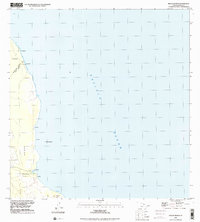
1994 Map of Keaau Ranch
USGS Topo · Published 2001About this map
The coastal interface of the South Hilo and Puna Districts defines this coastal landscape on the Big Island. Concentrated along the shoreline, several named coastal features like Anapuka, Paukūpahu, and Pāpa'i suggest a landscape shaped by volcanic activity meeting the Pacific Ocean. Most human activity is localized at the Kea'au Ranch, where a marked Cemetery and local structures sit near the junction of coastal 4wd tracks. This area maintains a largely undeveloped character, preserved within the Waiākea and Kea'au lands. Near the southern edge of the sheet, the terrain reaches Paki Bay and Kīpaepae, illustrating the primitive transit routes that connected these isolated ranching and coastal points before modern infrastructure dominated the region.
Find a feature on this map
17 named features on this map. Tap any name to fly to it.
Don’t see what you’re looking for? This feature index may not catch every label — zoom into the map to look around manually.
Map Details
Editions of this 1994 Keaau Ranch Map
This is the sole edition of this map. No revisions or reprints were ever made.
Other maps of this area

1915 · Honomu
USGS Topo · 1:62,500

1917 · Hilo
USGS Topo · 1:62,500

1924 · Makuu
USGS Topo · 1:62,500

1932 · Hilo
USGS Topo · 1:62,500

1954 · Hawaii North
USGS Topo · 1:250,000

1959 · Hawaii North
USGS Topo · 1:250,000

1961 · Hawaii North
USGS Topo · 1:250,000
1963 · Hilo
USGS Topo · 1:24,000
1963 · Keaau Ranch
USGS Topo · 1:24,000
1963 · Mountain View
USGS Topo · 1:24,000