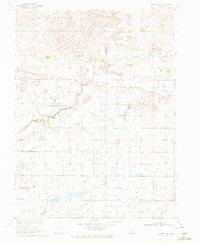
1970 Map of Kearney SW
USGS Topo · Published 1972About this map
North Creek meanders through this agricultural landscape in the Missouri River Basin, crossing the boundary between Phelps and Kearney counties. The terrain is defined by the high ground of Cottonwood and Divide, which separate the natural drainage of Anderson Creek and Blaine Creek from the engineered waterways to the south. The presence of an Aqueduct and a Canal near the township of Mirage indicates the sophisticated irrigation and water management systems necessary for Nebraska farming during this era. Numerous small water wells are scattered across the township lines, marking individual homesteads and points of local resource extraction. This 1970 field-checked survey provides a detailed look at the rural infrastructure of the Central Plains, from the precise placement of a Gate to the intersection of township roads and county lines.
Find a feature on this map
11 named features on this map. Tap any name to fly to it.
Don’t see what you’re looking for? This feature index may not catch every label — zoom into the map to look around manually.
Map Details
Editions of this 1970 Kearney SW Map
This is the sole edition of this map. No revisions or reprints were ever made.
Other maps of this area

1894 · Kearney
USGS Topo · 1:62,500

1896 · Holdrege
USGS Topo · 1:125,000

1896 · Kearney
USGS Topo · 1:125,000

1955 · Grand Island
USGS Topo · 1:250,000

1957 · Grand Island
USGS Topo · 1:250,000

1958 · Grand Island
USGS Topo · 1:250,000

1962 · Elm Creek East
USGS Topo · 1:24,000
1962 · Kearney
USGS Topo · 1:24,000
1962 · Alfalfa Center
USGS Topo · 1:24,000

1970 · Holdrege East
USGS Topo · 1:24,000