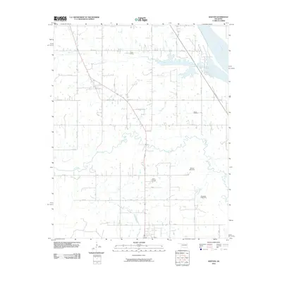
2010 Map of Keefton
USGS Topo · Published 2010About this map
Warner Mountain rises above the southeastern plains of Muskogee County, overlooking a landscape defined by the winding paths of Dirty Creek and Spaniard Creek. This 2010 survey illustrates the rural character of the area just south of the Arkansas River, where a grid of section roads like E 103rd St S and S 45th St E connects scattered farmsteads and family landholdings. The map is a valuable resource for genealogists, as it identifies several local burial grounds, including Warner Memorial Cemetery, Agnew Cemetery, and McLain Cemetery. The presence of the Muskogee Tpke slicing diagonally through the northern half shows the integration of modern infrastructure into this traditional agricultural setting. Water management is noted by the Oknoname 101016 Dam, which regulates local drainage south of the mountain.
Find a feature on this map
36 named features on this map. Tap any name to fly to it.
Don’t see what you’re looking for? This feature index may not catch every label — zoom into the map to look around manually.
Map Details
Editions of this 2010 Keefton Map
This is the sole edition of this map. No revisions or reprints were ever made.
Other maps of this area

1900 · Sansbois
USGS Topo · 1:125,000

1901 · Muscogee
USGS Topo · 1:125,000

1905 · Muscogee
USGS Topo · 1:125,000

1909 · Sans Bois
USGS Topo · 1:125,000

1911 · Sansbois
USGS Topo · 1:125,000

1946 · Fort Smith
USGS Topo · 1:250,000

1948 · Keefeton
USGS Topo · 1:62,500

1948 · Webbers Falls
USGS Topo · 1:62,500

1950 · Keefeton
USGS Topo · 1:62,500

1950 · Webbers Falls
USGS Topo · 1:62,500