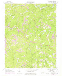
1968 Map of Keen Mountain
USGS Topo · Published 1978About this map
Keen Mountain serves as the central anchor for this 1960s study of Buchanan County's extractive landscape, where the Norfolk and Western railroad winds through the deep hollows of the Appalachian Plateau. The map documents an intensive era of energy production, evidenced by numerous strip mines and gas wells scattered across Henry Ridge and Dung Ridge. Small mountain communities such as Pilgrims Knob, Marvin, and Grimsleyville are situated along the narrow valley floors of the Levisa Fork and its tributaries. Local social geography is detailed through the placement of the Contrary Sch, Antioch Ch, and several family cemeteries. In the southern portion of the quadrangle, the meeting of the Buchanan, Russell, and Tazewell county lines at Shortt Gap highlights the political boundaries defined by these prominent ridges and gaps.
Find a feature on this map
92 named features on this map. Tap any name to fly to it.
Don’t see what you’re looking for? This feature index may not catch every label — zoom into the map to look around manually.
Map Details
Editions of this 1968 Keen Mountain Map
3 editions found
Other maps of this area

1886 · Grundy
USGS Topo · 1:125,000

1890 · Grundy
USGS Topo · 1:125,000

1891 · Tazewell
USGS Topo · 1:125,000

1892 · Grundy
USGS Topo · 1:125,000

1895 · Tazewell
USGS Topo · 1:125,000

1897 · Tazewell
USGS Topo · 1:125,000

1910 · Iaeger
USGS Topo · 1:48,000

1912 · Iaeger
USGS Topo · 1:62,500

1914 · Bucu
USGS Topo · 1:48,000

1914 · Iaeger
USGS Topo · 1:48,000