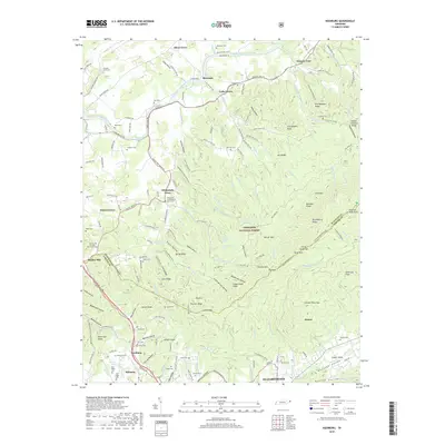
2019 Map of Keenburg
USGS Topo · Published 2019About this map
Silver Grove and Riverside sit along the northern banks of the South Fork Holston River, where the river's path winds through a landscape of ridges and family-named gaps. This 2019 survey captures the interface between the agricultural valley communities and the densely forested slopes of the Cherokee National Forest. To the south, the settlement of Keenburg and the neighborhood of Biltmore mark the northern outskirts of Elizabethton, showing how the modern road network follows the historic contours of the Watauga Valley. High points like Grandfather Knob and Holston High Point overlook a terrain dotted with numerous family cemeteries, including Crockett Cem and Webb Cem, providing significant geographic context for genealogical research. The map illustrates a region where local identity remains tied to distinct church-centered communities like Chinquapin Grove and Bunker Hill.
Find a feature on this map
184 named features on this map. Tap any name to fly to it.
Don’t see what you’re looking for? This feature index may not catch every label — zoom into the map to look around manually.
Map Details
Editions of this 2019 Keenburg Map
This is the sole edition of this map. No revisions or reprints were ever made.
Other maps of this area

1891 · Roan Mountain
USGS Topo · 1:125,000

1894 · Roan Mountain
USGS Topo · 1:125,000

1897 · Bristol
USGS Topo · 1:125,000

1902 · Bristol
USGS Topo · 1:125,000

1904 · Roan Mountain
USGS Topo · 1:125,000

1934 · Holston Valley
USGS Topo · 1:24,000

1934 · Bristol
USGS Topo · 1:24,000

1935 · Watauga Valley
USGS Topo · 1:48,000

1935 · Blountville
USGS Topo · 1:24,000
1935 · Carter
USGS Topo · 1:24,000