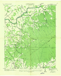
1935 Map of Keenburg
USGS Topo · Published 1935About this map
The South Fork Holston River winds through this 1935 landscape, marking a period of diverse rural industry and settlement in Sullivan and Carter counties. Industrial activity is concentrated near Keenburg and Biltmore, where the Southern Railway corridor supports Brick Kilns and a Limestone Quarry. Further into the hills, the Old Bauxite Mines and local infrastructure like McCaneys Mill and Adams Mill point to an economy deeply tied to the land's mineral and water resources. The terrain is characterized by the slopes of Holston Mountain and Unaka Mountain, within which the Cherokee National Forest boundary begins. Social life of the era is anchored by small rural centers such as Hickory Tree and Chinquapin Grove, alongside Numerous country schools including Mt Holston Sch and Walnut Grove Sch. This survey also documents early recreational and conservation efforts, noting the Appalachian Trail crossing the mountain ridges and the Underwood Spring serving the nearby population.
Find a feature on this map
93 named features on this map. Tap any name to fly to it.
Don’t see what you’re looking for? This feature index may not catch every label — zoom into the map to look around manually.
Map Details
Editions of this 1935 Keenburg Map
This is the sole edition of this map. No revisions or reprints were ever made.
Other maps of this area

1891 · Roan Mountain
USGS Topo · 1:125,000

1894 · Roan Mountain
USGS Topo · 1:125,000

1897 · Bristol
USGS Topo · 1:125,000

1902 · Bristol
USGS Topo · 1:125,000

1904 · Roan Mountain
USGS Topo · 1:125,000

1934 · Holston Valley
USGS Topo · 1:24,000

1934 · Bristol
USGS Topo · 1:24,000

1935 · Watauga Valley
USGS Topo · 1:48,000

1935 · Blountville
USGS Topo · 1:24,000
1935 · Carter
USGS Topo · 1:24,000