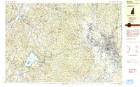
1984 Map of Keene
USGS Topo · Published 1984About this map
The Ashuelot River valley serves as the anchor for the city of Keene in this mid-1980s topographic survey, which documents a region defined by its educational and transport infrastructure. The downtown area is dominated by the campus of Keene State College, while the Dillant-Hopkins Airport and the Boston and Maine railroad line reflect the city's role as a regional hub for Cheshire County. To the west, the terrain rises sharply toward family-named peaks such as Hyland Hill—capped by the Hyland Hill Lookout Station—and Windy Hill.
Find a feature on this map
50 named features on this map. Tap any name to fly to it.
Don’t see what you’re looking for? This feature index may not catch every label — zoom into the map to look around manually.
Map Details
Editions of this 1984 Keene Map
2 editions found
Other maps of this area

1891 · Brattleboro
USGS Topo · 1:62,500

1893 · Brattleboro
USGS Topo · 1:62,500

1898 · Monadnock
USGS Topo · 1:62,500

1898 · Keene
USGS Topo · 1:62,500

1927 · Bellows Falls
USGS Topo · 1:48,000

1930 · Saxtons River
USGS Topo · 1:48,000

1930 · Lovewell Mountain
USGS Topo · 1:62,500

1930 · Bellows Falls
USGS Topo · 1:62,500

1932 · Brattleboro
USGS Topo · 1:48,000

1932 · Keene
USGS Topo · 1:62,500