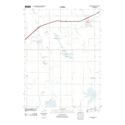
2010 Map of Keenesburg
USGS Topo · Published 2010About this map
The town of Keenesburg and the smaller settlement of Roy anchor this 2010 landscape of eastern Colorado, defined by an intricate network of irrigation and water storage. This map reveals the agricultural engineering essential to the High Plains, where the Denver-Hudson Canal, Henrylyn Canal, and numerous laterals like the Keen Lateral distribute water across the grid. Significant water bodies dominate the southern and central sections, including Prospect Reservoir, Horse Creek Reservoir, and the Banner Lakes complex. Each reservoir is supported by specific infrastructure such as the Horse Creek Dam and Banner Lake Number 5 Dam. Aviation is a notable part of the local character, with three small airfields — Hayes Airport, Land Airport, and Lindys Airpark — scattered among the irrigation channels and county roads. The map provides a precise record of late 20th and early 21st-century water management, showing how the landscape is divided between major drainages like Box Elder Creek and the man-made canals that sustain the region.
Find a feature on this map
58 named features on this map. Tap any name to fly to it.
Don’t see what you’re looking for? This feature index may not catch every label — zoom into the map to look around manually.
Map Details
Editions of this 2010 Keenesburg Map
This is the sole edition of this map. No revisions or reprints were ever made.
Other maps of this area

1890 · East Denver
USGS Topo · 1:125,000

1902 · Greeley
USGS Topo · 1:125,000

1942 · Mile High Lakes
USGS Topo · 1:31,680

1949 · Sunnydale
USGS Topo · 1:24,000

1949 · Hudson
USGS Topo · 1:24,000

1950 · Tampa
USGS Topo · 1:24,000

1950 · Keenesburg
USGS Topo · 1:24,000

1950 · Prospect Valley
USGS Topo · 1:24,000

1950 · Klug Ranch
USGS Topo · 1:24,000
1950 · Milton Reservoir
USGS Topo · 1:24,000