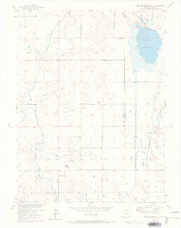
1950 Map of Milton Reservoir
USGS Topo · Published 1973About this map
Milton Reservoir dominates the northeastern landscape of this Weld County agricultural region, serving as a vital hub for an intricate network of irrigation infrastructure. This 1950s study, updated with 1971 aerial observations, reveals how water management shaped the high plains, featuring the Speer East Canal, Speer West Canal, and Beebe Seep Canal alongside several ditches. These waterways cut through a landscape dotted with numerous windmills and wells, essential for livestock and homesteads.
Find a feature on this map
16 named features on this map. Tap any name to fly to it.
Don’t see what you’re looking for? This feature index may not catch every label — zoom into the map to look around manually.
Map Details
Editions of this 1950 Milton Reservoir Map
3 editions found
Other maps of this area

1902 · Greeley
USGS Topo · 1:125,000

1949 · Fort Lupton
USGS Topo · 1:24,000

1949 · Platteville
USGS Topo · 1:24,000

1949 · Hudson
USGS Topo · 1:24,000

1950 · Platteville
USGS Topo · 1:24,000
1950 · Fort Lupton
USGS Topo · 1:24,000

1950 · Keenesburg
USGS Topo · 1:24,000

1950 · Milliken
USGS Topo · 1:24,000

1950 · Klug Ranch
USGS Topo · 1:24,000

1950 · Valley View School
USGS Topo · 1:24,000