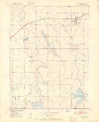
1951 Map of Keenesburg
USGS Topo · Published 1951About this map
The high plains of Colorado in the early 1950s reveal a landscape defined by an intricate network of irrigation, centered on the settlement of Keenesburg. This agricultural infrastructure is anchored by a series of significant water storage projects, including the Horse Creek Reservoir, Prospect Reservoir, and Lott Reservoir, along with numerous private holdings such as the Ireland Res No One series and De Remer Lakes. The transit of water is managed through a complex system of named ditches and flumes, like the Denver Hudson Canal and the Quincy Canal, which carve through the drainages of Box Elder Creek and Horse Creek. The Chicago Burlington and Quincy railroad line provides the primary industrial backbone for the region, running parallel to the Burlington No 2 Lateral as it passes through the heart of the town. This survey illustrates the intensive engineering required to sustain homesteads and ranching in a semi-arid environment, marked by numerous wells and windmills across the Weld and Adams County line.
Find a feature on this map
24 named features on this map. Tap any name to fly to it.
Don’t see what you’re looking for? This feature index may not catch every label — zoom into the map to look around manually.
Map Details
Editions of this 1951 Keenesburg Map
2 editions found

Other maps of this area

1890 · East Denver
USGS Topo · 1:125,000

1902 · Greeley
USGS Topo · 1:125,000

1942 · Mile High Lakes
USGS Topo · 1:31,680

1949 · Sunnydale
USGS Topo · 1:24,000

1949 · Hudson
USGS Topo · 1:24,000

1950 · Tampa
USGS Topo · 1:24,000

1950 · Keenesburg
USGS Topo · 1:24,000

1950 · Prospect Valley
USGS Topo · 1:24,000

1950 · Klug Ranch
USGS Topo · 1:24,000
1950 · Milton Reservoir
USGS Topo · 1:24,000