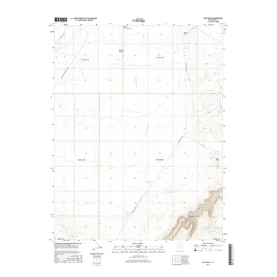
2017 Map of Keg Knoll
USGS Topo · Published 2017About this map
Antelope Valley dominates this high-desert landscape in Emery County, where a network of ephemeral washes and isolated water sources defined movement and livestock management in the early 21st century. The terrain is marked by significant topographical shifts, from the prominent Keg Knoll to the winding depths of Horseshoe Canyon and the carved path of Barrier Cr. This environment requires intentional water management, evidenced by the Antelope Valley Number Three Reservoir, Big Pond, and Kirby Pond. Human activity is primarily limited to rugged transportation routes like the Lower San Rafael Rd and Saucer Basin Rd, which provide access to these remote reaches. The presence of Keg Spring and Johns Spring indicates the critical importance of reliable water points in an otherwise arid expanse of public land managed by the Bureau of Land Management.
Find a feature on this map
22 named features on this map. Tap any name to fly to it.
Don’t see what you’re looking for? This feature index may not catch every label — zoom into the map to look around manually.
Map Details
Editions of this 2017 Keg Knoll Map
This is the sole edition of this map. No revisions or reprints were ever made.
Other maps of this area

1885 · San Rafael
USGS Topo · 1:250,000

1952 · Tidwell 4 SE
USGS Topo · 1:24,000

1952 · Tidwell 4 NE
USGS Topo · 1:24,000

1953 · Orange Cliffs 1 NE
USGS Topo · 1:24,000

1953 · The Spur
USGS Topo · 1:62,500

1956 · Salina
USGS Topo · 1:250,000

1960 · Salina
USGS Topo · 1:250,000

1962 · Salina
USGS Topo · 1:250,000

1963 · Robbers Roost Canyon
USGS Topo · 1:62,500
1963 · Bowknot Bend
USGS Topo · 1:62,500