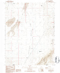
1986 Map of Keg Knoll
USGS Topo · Published 1987About this map
Antelope Valley dominates this high-desert landscape on the border of Emery and Wayne counties. The geography is defined by a series of intermittent drainage systems and essential water sources, including the Antelope Valley No 3 Reservoir and several named ponds like Big Pond and Kirby Pond. These features highlight the importance of water management in this arid region of Utah during the late 20th century. Toward the eastern edge, the topography becomes more complex around Keg Knoll and the descent into Horseshoe Canyon Creek. Traditional land use is evident through the network of 4wd trails and isolated improvements such as the Saucer Basin Well and Old Man Spring. This provisional survey provides a precise look at the drainage patterns of Antelope Valley Wash and the surrounding high ground at Lookout Point before more modern developments changed the character of these backcountry areas.
Find a feature on this map
15 named features on this map. Tap any name to fly to it.
Don’t see what you’re looking for? This feature index may not catch every label — zoom into the map to look around manually.
Map Details
Editions of this 1986 Keg Knoll Map
This is the sole edition of this map. No revisions or reprints were ever made.
Other maps of this area

1885 · San Rafael
USGS Topo · 1:250,000

1952 · Tidwell 4 SE
USGS Topo · 1:24,000

1952 · Tidwell 4 NE
USGS Topo · 1:24,000

1953 · Orange Cliffs 1 NE
USGS Topo · 1:24,000

1953 · The Spur
USGS Topo · 1:62,500

1956 · Salina
USGS Topo · 1:250,000

1960 · Salina
USGS Topo · 1:250,000

1962 · Salina
USGS Topo · 1:250,000

1963 · Robbers Roost Canyon
USGS Topo · 1:62,500
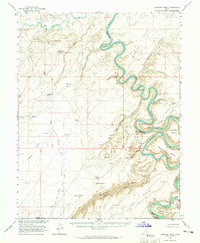
1963 · Bowknot Bend
USGS Topo · 1:62,500