1971 Map of Kelliher
USGS Topo · Published 1974About this map
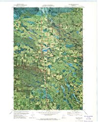
Kelliher serves as the primary hub in this northern Minnesota landscape, where the managed timberlands of the Red Lake State Forest and Pine Island State Forest converge. This early 1970s orthophotomap provides a clear view of the intersection between human settlement and the extensive wetlands of the region. Local landmarks such as St Joseph Ch and the Kelliher Cem are documented alongside the village's infrastructure, including a Lookout Tower and the Meadow Landing Strip. The drainage patterns of the South Branch Battle River and the waters of Bullhead Lake define the terrain, which is further shaped by the Shooks River Wildlife Management Area. Historical transit routes are preserved on the sheet, notably the Winter Trail, reflecting the seasonal adaptations required for travel across these northern boglands and forests.
Find a feature on this map
15 named features on this map. Tap any name to fly to it.
Don’t see what you’re looking for? This feature index may not catch every label — zoom into the map to look around manually.
Map Details
Editions of this 1971 Kelliher Map
This is the sole edition of this map. No revisions or reprints were ever made.
Other maps of this area

1919 · Fox
USGS Topo · 1:62,500

1919 · Quiring
USGS Topo · 1:62,500

1919 · Norden
USGS Topo · 1:62,500

1919 · Bridgie
USGS Topo · 1:62,500

1924 · Bridgie
USGS Topo · 1:62,500

1954 · Bemidji
USGS Topo · 1:250,000

1954 · Roseau
USGS Topo · 1:250,000

1957 · Roseau
USGS Topo · 1:250,000

1957 · Bemidji
USGS Topo · 1:250,000

1958 · Bemidji
USGS Topo · 1:250,000