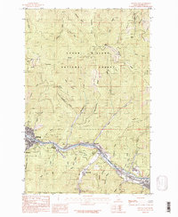
1985 Map of Kellogg East
USGS Topo · Published 1985About this map
The South Fork Coeur d'Alene River valley serves as the industrial and residential corridor for this portion of the Idaho Panhandle, anchoring the mining-heavy landscape of the Coeur d'Alene National Forest. Settlements like Kellogg, Wardner, and Osburn are tightly clustered along the river and the main transportation lines, reflecting the geographic constraints of the narrow valley floor. The map shows a clear division between the developed riverbanks, featuring a Golf Course and the residential area of Elizabeth Park, and the surrounding high country marked by a dense network of gulches and ridges. Local industry and prospecting history are evident in the numerous labels for prospects and mining-related features scattered throughout Deceitful Gulch, Moon Gulch, and Montgomery Gulch. Above the valley, the terrain is defined by prominent landmarks such as Character Ridge and White Peak, crossed by several high-elevation trails.
Find a feature on this map
43 named features on this map. Tap any name to fly to it.
Don’t see what you’re looking for? This feature index may not catch every label — zoom into the map to look around manually.
Map Details
Editions of this 1985 Kellogg East Map
2 editions found
Other maps of this area

1901 · Coeur D'Alene District
USGS Topo · 1:62,500

1903 · Coeur D'Alene District
USGS Topo · 1:62,500

1906 · Coeur D'Alene District
USGS Topo · 1:62,500

1909 · Cataldo
USGS Topo · 1:125,000

1911 · Cataldo
USGS Topo · 1:125,000

1914 · Avery
USGS Topo · 1:125,000

1917 · Avery
USGS Topo · 1:125,000

1932 · Trout Creek
USGS Topo · 1:125,000

1935 · Trout Creek
USGS Topo · 1:125,000

1936 · Trout Creek
USGS Topo · 1:125,000