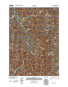
2011 Map of Kelly Butte
USGS Topo · Published 2011About this map
Bateman Lookout Tower stands as a central landmark in this high-elevation corner of Douglas County, overseeing a complex network of ridgelines and watercourses. This 2011 survey illustrates the intricate drainage patterns of the region, where the long spine of Bateman Ridge divides the landscape between the Lake Creek basin and the headwaters of Wolf Creek. The terrain is characterized by steep, timbered slopes and an extensive system of forest roads, including BLM Road 25-8-1.1. To the west, the prominent elevation of Kelly Butte overlooks the winding Fall Creek, while the eastern side of the quadrangle is dominated by the sharp features of Case Knife Ridge and Case Knife Creek. The map documents a landscape defined by industrial forest management and high-country hydrology, tracing the paths of numerous named tributaries like Whiskey Camp Creek and Bull Canyon Creek.
Find a feature on this map
22 named features on this map. Tap any name to fly to it.
Don’t see what you’re looking for? This feature index may not catch every label — zoom into the map to look around manually.
Map Details
Editions of this 2011 Kelly Butte Map
This is the sole edition of this map. No revisions or reprints were ever made.
Other maps of this area

1928 · Sitkum
USGS Topo · 1:125,000

1955 · Scottsburg
USGS Topo · 1:62,500

1955 · Ivers Peak
USGS Topo · 1:62,500

1955 · Tyee
USGS Topo · 1:62,500

1955 · Elkton
USGS Topo · 1:62,500

1958 · Roseburg
USGS Topo · 1:250,000

1959 · Roseburg
USGS Topo · 1:250,000

1979 · Roseburg
USGS Topo · 1:100,000

1979 · Cottage Grove
USGS Topo · 1:100,000
1985 · Loon Lake
USGS Topo · 1:24,000