
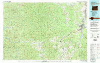
1979 Map of Cottage Grove
USGS Topo · Published 1979About this map
The Coast Fork Willamette River serves as the primary corridor for development through the eastern portion of this region, anchoring the growth of Cottage Grove and Creswell. This late-1970s landscape reveals a critical junction of transportation and timber, where the Southern Pacific railroad and Pacific Highway parallel the valley floors. To the west, the terrain transitions into the dense woodlands of the Siuslaw National Forest and the Umpqua State Forest, where numerous peaks like Roman Nose Mtn and Goodwin Peak Lookout define the skyline.
Find a feature on this map
47 named features on this map. Tap any name to fly to it.
Don’t see what you’re looking for? This feature index may not catch every label — zoom into the map to look around manually.
Map Details
Editions of this 1979 Cottage Grove Map
2 editions found
Other maps of this area

1896 · Coos Bay
USGS Topo · 1:125,000

1897 · Roseburg
USGS Topo · 1:125,000

1898 · Coos Bay
USGS Topo · 1:125,000

1900 · Roseburg
USGS Topo · 1:125,000

1900 · Coos Bay
USGS Topo · 1:125,000

1909 · Elmira
USGS Topo · 1:62,500

1910 · Eugene
USGS Topo · 1:62,500

1918 · Mapleton
USGS Topo · 1:48,000

1919 · Earl
USGS Topo · 1:48,000

1920 · Siltcoos Lake
USGS Topo · 1:62,500