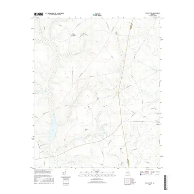
2017 Map of Kellys Pond
USGS Topo · Published 2017About this map
Ellis Plantation and the small town of Vidette anchor this portion of the coastal plain near the boundary of Jefferson and Burke counties. The landscape is defined by an intricate network of small watercourses including Big Creek, Schaffer Creek, and Thornton Creek, which feed into larger bodies like Kellys Pond and Greener Mill Pond. This terrain suggests a long-standing agricultural tradition, with numerous family burial grounds scattered across the acreage. Genealogists will find a wealth of local history in these locations, such as the Ponder Family Cemetery, Melton Place Cemetery, and Boatwright Cemetery. The layout of rural roads, including Old Louisville Road and Middleground Road, reflects a historical transport network connecting these isolated plantations and homesteads through the Georgia backcountry.
Find a feature on this map
62 named features on this map. Tap any name to fly to it.
Don’t see what you’re looking for? This feature index may not catch every label — zoom into the map to look around manually.
Map Details
Editions of this 2017 Kellys Pond Map
This is the sole edition of this map. No revisions or reprints were ever made.
Other maps of this area

1919 · Gough
USGS Topo · 1:62,500

1920 · Stapleton
USGS Topo · 1:62,500

1948 · Stapleton
USGS Topo · 1:62,500

1948 · Gough
USGS Topo · 1:62,500

1948 · Louisville
USGS Topo · 1:24,000

1950 · Louisville
USGS Topo · 1:24,000
1950 · Gough
USGS Topo · 1:24,000

1950 · Wrens
USGS Topo · 1:24,000
1950 · Keysville
USGS Topo · 1:24,000

1950 · Matthews
USGS Topo · 1:24,000