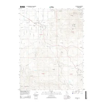
2015 Map of Kelseyville
USGS Topo · Published 2015About this map
The community of Kelseyville sits at the foot of the Clear Lake volcanic field, where the terrain shifts dramatically from the agricultural flats of Big Valley toward the heights of Mt Konocti. This 2015 survey documents the complex landscape of northern Lake County, showing the intersection of fruit orchards and vineyards with the volcanic peaks of Buckingham Peak and South Peak. The map provides a detailed view of local infrastructure, including the Kelseyville Cemetery and the residential pocket of Glenview to the southeast. Natural drainage patterns are clearly defined by Kelsey Creek and Cole Creek, which flow through valleys such as Shaul Valley. In the higher elevations, the presence of Boggs Lake, Carlsbad Spring, and Poison Smith Spring illustrates the unique hydrology of this geothermal region, while Storm Canyon cuts through the slopes of the Mayacmas Mountains to the southwest.
Find a feature on this map
74 named features on this map. Tap any name to fly to it.
Don’t see what you’re looking for? This feature index may not catch every label — zoom into the map to look around manually.
Map Details
Editions of this 2015 Kelseyville Map
This is the sole edition of this map. No revisions or reprints were ever made.
Other maps of this area

1921 · Kelseyville
USGS Topo · 1:62,500

1924 · Bartlett Springs
USGS Topo · 1:62,500

1938 · Lakeport
USGS Topo · 1:62,500

1942 · Bartlett Springs
USGS Topo · 1:62,500

1943 · Kelseyville
USGS Topo · 1:62,500

1944 · Bartlett Springs
USGS Topo · 1:62,500

1945 · Lower Lake
USGS Topo · 1:62,500

1947 · Santa Rosa
USGS Topo · 1:250,000

1949 · Santa Rosa
USGS Topo · 1:250,000

1951 · Lakeport
USGS Topo · 1:62,500