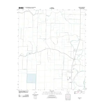
2011 Map of Kelso
USGS Topo · Published 2011About this map
Rohwer stands as a significant historical site in this Desha County landscape, notably marked by the Rohwer Relocation Center Cemetery. This area reflects the agrarian and industrial development of the Arkansas Delta, where the drainage of the land is managed through features like Canal Number 81 and the winding course of Cypress Creek. The settlement patterns are anchored by small communities such as Kelso and Duce, connected by an extensive grid of rural roads and lanes named for local families. This 2011 survey documents the proximity of several burial grounds, including the Rolling Water Cemetery, Kelso Cemetery, and Memorial Cemetery, which serve as vital markers for genealogical research in this region of eastern Arkansas.
Find a feature on this map
42 named features on this map. Tap any name to fly to it.
Don’t see what you’re looking for? This feature index may not catch every label — zoom into the map to look around manually.
Map Details
Editions of this 2011 Kelso Map
This is the sole edition of this map. No revisions or reprints were ever made.
Other maps of this area

1933 · Lamont
USGS Topo · 1:62,500

1935 · Red Fork
USGS Topo · 1:62,500

1936 · McGehee
USGS Topo · 1:62,500

1937 · McGehee
USGS Topo · 1:62,500

1939 · Big Island
USGS Topo · 1:62,500

1939 · Lamont
USGS Topo · 1:62,500

1953 · Greenwood
USGS Topo · 1:250,000

1955 · McGehee
USGS Topo · 1:62,500

1956 · Greenwood
USGS Topo · 1:250,000
1969 · Winchester
USGS Topo · 1:24,000