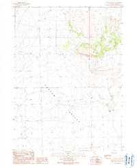
1990 Map of Kelton Pass SE
USGS Topo · Published 1990About this map
Curlew Valley dominates the southern expanse of this northern Utah landscape, where the wide basin floor meets the rising elevations of the Wildcat Hills to the northeast. Compiled from aerial photography in the early 1980s and field-checked in 1985, this record illustrates a sparse, arid territory primarily shaped by topography rather than dense settlement. The presence of a solitary Well in the western valley floor highlights the critical role of water management in this high-desert environment. The map provides a precise look at the drainage patterns and relief of the Wildcat Hills, offering a clear view of the natural terrain and essential desert landmarks as they existed toward the end of the twentieth century.
Find a feature on this map
3 named features on this map. Tap any name to fly to it.
Don’t see what you’re looking for? This feature index may not catch every label — zoom into the map to look around manually.
Map Details
Editions of this 1990 Kelton Pass SE Map
This is the sole edition of this map. No revisions or reprints were ever made.
Other maps of this area

1954 · Brigham City
USGS Topo · 1:250,000

1958 · Brigham City
USGS Topo · 1:250,000

1959 · Kelton Pass
USGS Topo · 1:62,500

1962 · Brigham City
USGS Topo · 1:250,000

1968 · Monument Peak NW
USGS Topo · 1:24,000

1968 · Monument Peak SW
USGS Topo · 1:24,000

1969 · Peplin Flats
USGS Topo · 1:24,000

1969 · Locomotive Springs
USGS Topo · 1:24,000

1969 · Crocodile Mtn NE
USGS Topo · 1:24,000

1987 · Grouse Creek
USGS Topo · 1:100,000