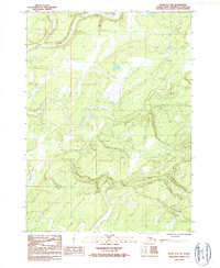
1987 Map of Kenai A-4 SW
USGS Topo · Published 1987About this map
The Ninilchik River meanders through the northern portion of this Kenai Peninsula terrain, defining the local drainage patterns as they were documented in the mid-1980s. This provisional survey captures a landscape of seasonal movement and sparse habitation, evidenced by the presence of a single isolated Cabin and a network of pathways including a designated Winter Trail. These routes were essential for navigating the interior when frozen ground allowed for easier passage through the wetlands and river valleys. In the southwest, Silver Salmon Creek cuts through the topography, while a Gravel Pit near the southern boundary suggests localized resource extraction for road maintenance. This 1987 edition, based on 1984 field checks, serves as a specific record of the peninsula's interior before more modern developments or shifts in land use changed the character of these backcountry corridors.
Find a feature on this map
6 named features on this map. Tap any name to fly to it.
Don’t see what you’re looking for? This feature index may not catch every label — zoom into the map to look around manually.
Map Details
Editions of this 1987 Kenai A-4 SW Map
This is the sole edition of this map. No revisions or reprints were ever made.
Other maps of this area

1944 · Kenai
USGS Topo · 1:250,000

1946 · Seldovia D-5
USGS Topo · 1:63,360

1949 · Seldovia D-4
USGS Topo · 1:63,360

1950 · Kenai
USGS Topo · 1:250,000

1951 · Seldovia D-5
USGS Topo · 1:63,360

1951 · Seldovia D-4
USGS Topo · 1:63,360

1951 · Seldovia
USGS Topo · 1:250,000

1951 · Kenai A-5
USGS Topo · 1:63,360

1951 · Kenai A-4
USGS Topo · 1:63,360

1952 · Kenai A-5
USGS Topo · 1:63,360