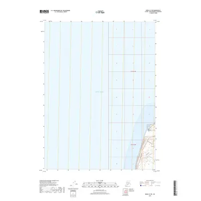
2018 Map of Kenai A-5 SW
USGS Topo · Published 2018About this map
Cape Ninilchik projects into the eastern reaches of the Pacific Ocean, anchoring a coastal landscape defined by the arterial Sterling Highway. This 2018 survey documents a pocket of residential and infrastructure development on the Kenai Peninsula, where a network of local thoroughfares like Tidal Knoll Road and Deep Creek Road branch off toward the shoreline. The transition from the marine environment to the inland plateau is marked by a series of residential loops and drives, including Arcturus Loop, Kiana Drive, and Berussa Road. The map provides a clear look at the modern cadastral grid and transportation corridors that shape this portion of the Kenai Peninsula Borough, illustrating how human settlement conforms to the narrow strip between the rising terrain and the sea.
Find a feature on this map
10 named features on this map. Tap any name to fly to it.
Don’t see what you’re looking for? This feature index may not catch every label — zoom into the map to look around manually.
Map Details
Editions of this 2018 Kenai A-5 SW Map
This is the sole edition of this map. No revisions or reprints were ever made.
Other maps of this area

1944 · Kenai
USGS Topo · 1:250,000

1946 · Seldovia D-5
USGS Topo · 1:63,360

1950 · Kenai
USGS Topo · 1:250,000

1951 · Seldovia D-5
USGS Topo · 1:63,360

1951 · Seldovia
USGS Topo · 1:250,000

1951 · Kenai A-5
USGS Topo · 1:63,360

1952 · Kenai A-5
USGS Topo · 1:63,360

1958 · Kenai
USGS Topo · 1:250,000
1961 · Seldovia D-5
USGS Topo · 1:63,360

1963 · Seldovia
USGS Topo · 1:250,000