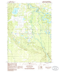
1986 Map of Kenai B-2 NW
USGS Topo · Published 1986About this map
The Kenai River meanders through a labyrinth of wetlands and glacial lakes in this mid-1980s look at the Alaskan interior. This landscape is defined by the expansive Kenai National Wildlife Refuge, where complex hydrologic systems feed into major tributaries like the Upper Killey River and Funny River. The map reveals a wild, roadless territory punctuated only by a few scattered trails and the established Wilderness Boundary. A network of remote water bodies, including Browns Lake, Hunters Lake, and the small Tea Lake, reflects the post-glacial topography of the Kenai Wilderness. This survey preserves the state of the peninsula's ecosystem before modern changes, documenting the natural drainage patterns and shoreline configurations of Sahot Lake and Torpedo Lake.
Find a feature on this map
11 named features on this map. Tap any name to fly to it.
Don’t see what you’re looking for? This feature index may not catch every label — zoom into the map to look around manually.
Map Details
Editions of this 1986 Kenai B-2 NW Map
This is the sole edition of this map. No revisions or reprints were ever made.
Other maps of this area

1944 · Kenai
USGS Topo · 1:250,000

1950 · Kenai
USGS Topo · 1:250,000

1950 · Kenai C-3
USGS Topo · 1:63,360

1950 · Kenai B-3
USGS Topo · 1:63,360

1951 · Kenai B-2
USGS Topo · 1:63,360

1951 · Kenai C-2
USGS Topo · 1:63,360

1951 · Kenai C-3
USGS Topo · 1:63,360

1952 · Kenai C-2
USGS Topo · 1:63,360

1952 · Kenai B-3
USGS Topo · 1:63,360

1952 · Kenai B-2
USGS Topo · 1:63,360