
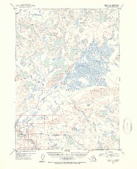
1952 Map of Kenai C-2
USGS Topo · Published 1954About this map
The Kenai National Moose Range dominates this mid-century landscape of the Kenai Peninsula, where a complex network of wetlands and rivers transitions into the early development of the region's interior. The southern edge of the sheet shows the alignment of the Sterling Highway as it parallels the Kenai River, serving as the primary corridor for human activity. Near the river, the Naptowne Lodge and an adjacent Landing Strip mark a hub for backcountry access and transportation.
Find a feature on this map
13 named features on this map. Tap any name to fly to it.
Don’t see what you’re looking for? This feature index may not catch every label — zoom into the map to look around manually.
Map Details
Editions of this 1952 Kenai C-2 Map
2 editions found
Other maps of this area

1944 · Kenai
USGS Topo · 1:250,000

1950 · Kenai
USGS Topo · 1:250,000

1950 · Kenai C-3
USGS Topo · 1:63,360

1950 · Kenai B-1
USGS Topo · 1:63,360

1950 · Kenai B-3
USGS Topo · 1:63,360

1951 · Kenai D-3
USGS Topo · 1:63,360

1951 · Kenai B-2
USGS Topo · 1:63,360

1951 · Kenai C-1
USGS Topo · 1:63,360

1951 · Kenai C-2
USGS Topo · 1:63,360

1951 · Kenai D-1
USGS Topo · 1:63,360