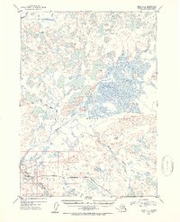
1952 Map of Kenai C-2
USGS Topo · Published 1954About this map
The Kenai National Moose Range dominates this mid-century landscape on the Kenai Peninsula, where a complex network of waterways like the West Fork Moose River and East Fork Moose River carve through the terrain. The presence of Naptowne Lodge and a nearby Landing Strip south of the Swanson River illustrates the early infrastructure for recreation and transport in this part of the Third Judicial Division.
Find a feature on this map
12 named features on this map. Tap any name to fly to it.
Don’t see what you’re looking for? This feature index may not catch every label — zoom into the map to look around manually.
Map Details
Editions of this 1952 Kenai C-2 Map
2 editions found

Other maps of this area

1944 · Kenai
USGS Topo · 1:250,000

1950 · Kenai
USGS Topo · 1:250,000

1950 · Kenai C-3
USGS Topo · 1:63,360

1950 · Kenai B-1
USGS Topo · 1:63,360

1950 · Kenai B-3
USGS Topo · 1:63,360

1951 · Kenai D-3
USGS Topo · 1:63,360

1951 · Kenai B-2
USGS Topo · 1:63,360

1951 · Kenai C-1
USGS Topo · 1:63,360

1951 · Kenai C-2
USGS Topo · 1:63,360

1951 · Kenai D-1
USGS Topo · 1:63,360