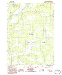
1986 Map of Kenai B-3 NE
USGS Topo · Published 1986About this map
Kenai River and Funny River converge in this mid-1980s topographic study of the Kenai Peninsula. The landscape is largely defined by the expansive Kenai National Wildlife Refuge, which covers the southern and eastern portions of the map, and is demarcated by a formal Wilderness Boundary. Human activity is concentrated along the river corridors and near Longmere Lake, featuring a scattered network of unimproved roads and a small Landing Strip indicative of the region's bush aviation reliance. Small-scale industrial traces, such as a Gravel Pit, sit near the primary waterways, while the interior remains a complex of wetlands and varying elevations typical of the Alaskan wilderness before more modern development.
Find a feature on this map
7 named features on this map. Tap any name to fly to it.
Don’t see what you’re looking for? This feature index may not catch every label — zoom into the map to look around manually.
Map Details
Editions of this 1986 Kenai B-3 NE Map
This is the sole edition of this map. No revisions or reprints were ever made.
Other maps of this area

1944 · Kenai
USGS Topo · 1:250,000

1950 · Kenai
USGS Topo · 1:250,000

1950 · Kenai C-3
USGS Topo · 1:63,360

1950 · Kenai B-3
USGS Topo · 1:63,360

1951 · Kenai B-2
USGS Topo · 1:63,360

1951 · Kenai C-2
USGS Topo · 1:63,360

1951 · Kenai C-3
USGS Topo · 1:63,360

1952 · Kenai C-2
USGS Topo · 1:63,360

1952 · Kenai B-3
USGS Topo · 1:63,360

1952 · Kenai B-2
USGS Topo · 1:63,360