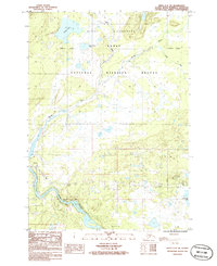
1986 Map of Kenai C-2 SW
USGS Topo · Published 1986About this map
Sterling and Naptowne occupy the lower portion of this mid-1980s survey, marking a pocket of development amidst the protected lands of the Kenai National Wildlife Refuge. The landscape is dominated by the winding course of the Kenai River, which features the notable Naptowne Rapids near the western edge of the settlement area. To the north, the terrain transitions into the Kenai Wilderness, characterized by a dense network of water bodies including Grebe Lake, Beaver Pond Lake, and the meandering Moose River. Infrastructure such as a pipeline, a Pumping Station, and a Landing Strip illustrate the logistical demands of the region's energy and transportation sectors during this era. Scattered Gravel Pits and Drill Holes suggest localized industrial activity within the broader conservation landscape.
Find a feature on this map
20 named features on this map. Tap any name to fly to it.
Don’t see what you’re looking for? This feature index may not catch every label — zoom into the map to look around manually.
Map Details
Editions of this 1986 Kenai C-2 SW Map
This is the sole edition of this map. No revisions or reprints were ever made.
Other maps of this area

1944 · Kenai
USGS Topo · 1:250,000

1950 · Kenai
USGS Topo · 1:250,000

1950 · Kenai C-3
USGS Topo · 1:63,360

1950 · Kenai B-3
USGS Topo · 1:63,360

1951 · Kenai B-2
USGS Topo · 1:63,360

1951 · Kenai C-2
USGS Topo · 1:63,360

1951 · Kenai C-3
USGS Topo · 1:63,360

1952 · Kenai C-2
USGS Topo · 1:63,360

1952 · Kenai B-3
USGS Topo · 1:63,360

1952 · Kenai B-2
USGS Topo · 1:63,360