1950 Map of Kenai
USGS Topo · Published 1950About this map
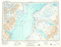
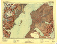
Redoubt Volcano and the massive Harding Ice Field dominate the rugged geography of the Kenai Peninsula in this mid-century survey. The landscape is defined by the powerful drainage systems of the Kenai River and Kasilof River, which flow from the interior Skilak Lake and Tustumena Lake toward the Cook Inlet. The map captures a moment of transition for the region, showing the established Sterling Highway corridor alongside older maritime and homesteading patterns. Evidence of shifting populations appears at Salamatof (Abandoned), while the economic life of the coast is anchored by features like the Snug Harbor Cannery and the Landing Field at Kenai. Interior land use is represented by isolated outposts such as Stetters Ranch and the Chickaloon Ski-Mobile Trail, reflecting the specialized transport required for this subarctic wilderness.
Find a feature on this map
99 named features on this map. Tap any name to fly to it.
Don’t see what you’re looking for? This feature index may not catch every label — zoom into the map to look around manually.
Map Details
Editions of this 1950 Kenai Map
2 editions found

Historical Maps of Kenai Through Time
3 maps found