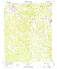
1966 Map of Kenbridge West
USGS Topo · Published 1977About this map
The town of Victoria and the western edge of Kenbridge serve as the primary anchors of this Lunenburg County survey, connected by the prominent Norfolk and Western rail corridor. This mid-century landscape is defined by its transition from small urban centers to rural crossroads like Oral Oaks and Sneads Corner. Local institutions are densely mapped, including Lunenburg High Sch and Central High Sch, along with numerous community landmarks such as West Hill Ch and Good Hope Ch.
Find a feature on this map
33 named features on this map. Tap any name to fly to it.
Don’t see what you’re looking for? This feature index may not catch every label — zoom into the map to look around manually.
Map Details
Editions of this 1966 Kenbridge West Map
3 editions found
Other maps of this area

1891 · Farmville
USGS Topo · 1:125,000

1893 · Farmville
USGS Topo · 1:125,000

1947 · Roanoke
USGS Topo · 1:250,000

1953 · Greensboro
USGS Topo · 1:250,000

1954 · Greensboro
USGS Topo · 1:250,000

1955 · Chase City
USGS Topo · 1:62,500

1955 · Kenbridge
USGS Topo · 1:62,500

1958 · Crewe
USGS Topo · 1:62,500

1958 · Keysville
USGS Topo · 1:62,500

1959 · Roanoke
USGS Topo · 1:250,000