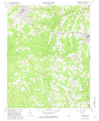
1966 Map of Kenbridge West
USGS Topo · Published 1982About this map
The Norfolk And Western railroad corridor anchors the northern half of this Lunenburg County landscape, connecting the primary settlements of Victoria and Kenbridge. This mid-century survey reveals a transition in rural life, where long-established country institutions like Mt Bethel Ch and West Hill Ch sit alongside emerging modern infrastructure, including the Lunenburg County Airport and the county Landfill. Educational history is well-represented by the locations of Central High Sch and Lunenburg High Sch, while local genealogical interest is centered on community burial sites such as Kenbridge Heights Cemetery, Oakwood Cem, and Lakeview Cem. The southern reach of the sheet remains largely rural and agrarian, defined by the winding paths of Flat Rock Creek and Reedy Creek, with smaller hubs like Oral Oaks and Sneads Corner serving as points of reference for the surrounding farmsteads.
Find a feature on this map
31 named features on this map. Tap any name to fly to it.
Don’t see what you’re looking for? This feature index may not catch every label — zoom into the map to look around manually.
Map Details
Editions of this 1966 Kenbridge West Map
3 editions found
Other maps of this area

1891 · Farmville
USGS Topo · 1:125,000

1893 · Farmville
USGS Topo · 1:125,000

1947 · Roanoke
USGS Topo · 1:250,000

1953 · Greensboro
USGS Topo · 1:250,000

1954 · Greensboro
USGS Topo · 1:250,000

1955 · Chase City
USGS Topo · 1:62,500

1955 · Kenbridge
USGS Topo · 1:62,500

1958 · Crewe
USGS Topo · 1:62,500

1958 · Keysville
USGS Topo · 1:62,500

1959 · Roanoke
USGS Topo · 1:250,000