
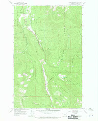
2014 Map of Kenelty Mountain
USGS Topo · Published 2014About this map
Kootenai National Forest encompasses the majority of this landscape in Lincoln County, where the topography is defined by prominent peaks and complex drainage systems. Kenelty Mtn and Wapiti Mtn dominate the central and eastern portions of the quadrangle, while the low-lying areas are shaped by the Fisher River and its various forks. The confluence of the Pleasant Valley Fisher River and the Silver Butte Fisher River creates a central valley corridor that has historically supported local transit and small settlements like Sedlak Park and Pleasant Valley Park. Transportation relies on a network of mountain roads such as Mc Ginnis Meadows Rd and Houghton Creek Rd, which provide access to the dense timberlands. The map reveals how water bodies like Crystal Cr and Raven Cr carve deep through the forested slopes, illustrating the relationship between the high ridge lines and the river systems below.
Find a feature on this map
30 named features on this map. Tap any name to fly to it.
Don’t see what you’re looking for? This feature index may not catch every label — zoom into the map to look around manually.
Map Details
Editions of this 2014 Kenelty Mountain Map
This is the sole edition of this map. No revisions or reprints were ever made.
Other maps of this area

1920 · Jennings
USGS Topo · 1:125,000

1935 · Thompson Lakes
USGS Topo · 1:96,000

1937 · Thompson Falls
USGS Topo · 1:125,000

1942 · Thompson Lakes
USGS Topo · 1:125,000

1956 · Wallace
USGS Topo · 1:250,000

1957 · Kalispell
USGS Topo · 1:250,000

1960 · Kalispell
USGS Topo · 1:250,000

1960 · Wallace
USGS Topo · 1:250,000

1961 · Kalispell
USGS Topo · 1:250,000
1966 · Horse Mountain
USGS Topo · 1:24,000