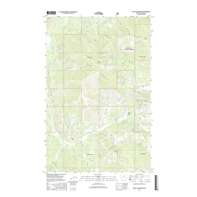
2017 Map of Kenelty Mountain
USGS Topo · Published 2017About this map
Kootenai National Forest dominates this mountain landscape in Lincoln County, defined by the drainage basins of the Fisher River and its major tributaries. The terrain is anchored by several prominent peaks, including Kenelty Mtn, Fritz Mtn, and Jumbo Peak in the southwest corner. The map traces the winding courses of the Pleasant Valley Fisher River and the Silver Butte Fisher River, which converge near Sedlak Park. The transport network is characterized by Forest Service roads like Houghton Creek Rd and backcountry routes such as the Divide Trail 6 (Kenelty). Evidence of regional travel history is preserved through the labeling of Old US Hwy 2, showing the evolution of the corridor through the Cabinet Mountains. This map serves as a detailed record of the intersections between water, wilderness, and managed forest land.
Find a feature on this map
38 named features on this map. Tap any name to fly to it.
Don’t see what you’re looking for? This feature index may not catch every label — zoom into the map to look around manually.
Map Details
Editions of this 2017 Kenelty Mountain Map
This is the sole edition of this map. No revisions or reprints were ever made.
Other maps of this area

1920 · Jennings
USGS Topo · 1:125,000

1935 · Thompson Lakes
USGS Topo · 1:96,000

1937 · Thompson Falls
USGS Topo · 1:125,000

1942 · Thompson Lakes
USGS Topo · 1:125,000

1956 · Wallace
USGS Topo · 1:250,000

1957 · Kalispell
USGS Topo · 1:250,000

1960 · Kalispell
USGS Topo · 1:250,000

1960 · Wallace
USGS Topo · 1:250,000

1961 · Kalispell
USGS Topo · 1:250,000
1966 · Horse Mountain
USGS Topo · 1:24,000