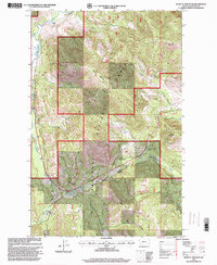
1997 Map of Kenelty Mountain
USGS Topo · Published 2000About this map
Kootenai National Forest dominates this landscape in Lincoln County, where the Fisher River carves a deep valley between high ridges. Grounded in a 1997 revision by the Forest Service, the map reflects a region defined by its hydrology and mountain summits. In the northern reaches, the confluence of Smoke Creek and Crystal Creek feeds into the main river channel, while prominent peaks like Kenelty Mountain and Wapiti Mountain define the skyline. Evidence of local administrative and educational history is found at the Raven Work Center and the Kenelty Sch, situated near the riverbanks. The survey also identifies managed recreation areas including Pleasant Valley Park and Sedley Park, illustrating the balance between wilderness management and public access in this mountainous interior of Montana.
Find a feature on this map
28 named features on this map. Tap any name to fly to it.
Don’t see what you’re looking for? This feature index may not catch every label — zoom into the map to look around manually.
Map Details
Editions of this 1997 Kenelty Mountain Map
This is the sole edition of this map. No revisions or reprints were ever made.
Other maps of this area

1920 · Jennings
USGS Topo · 1:125,000

1935 · Thompson Lakes
USGS Topo · 1:96,000

1937 · Thompson Falls
USGS Topo · 1:125,000

1942 · Thompson Lakes
USGS Topo · 1:125,000

1956 · Wallace
USGS Topo · 1:250,000

1957 · Kalispell
USGS Topo · 1:250,000

1960 · Kalispell
USGS Topo · 1:250,000

1960 · Wallace
USGS Topo · 1:250,000

1961 · Kalispell
USGS Topo · 1:250,000
1966 · Horse Mountain
USGS Topo · 1:24,000