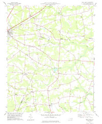
1978 Map of Kenly East
USGS Topo · Published 1978About this map
The town of Kenly sits at the intersection of heavy rail and local commerce in the late 1970s, where the Seaboard Coast Line railroad cuts diagonally across the coastal plain. The landscape is defined by its transition from organized agricultural land to the low-lying wetlands of Great Swamp and Nahunta Swamp. These swamps are fed by numerous branches like Brandy Branch and Peacock Br, creating a mosaic of drainage patterns that influenced the placement of early crossroads and mill sites.
Find a feature on this map
40 named features on this map. Tap any name to fly to it.
Don’t see what you’re looking for? This feature index may not catch every label — zoom into the map to look around manually.
Map Details
Editions of this 1978 Kenly East Map
This is the sole edition of this map. No revisions or reprints were ever made.
Other maps of this area

1902 · Kenly
USGS Topo · 1:62,500

1903 · Kenly
USGS Topo · 1:62,500

1904 · Wilson
USGS Topo · 1:62,500

1953 · Rocky Mount
USGS Topo · 1:250,000

1953 · Raleigh
USGS Topo · 1:250,000

1954 · Rocky Mount
USGS Topo · 1:250,000

1954 · Raleigh
USGS Topo · 1:250,000

1957 · Goldsboro
USGS Topo · 1:62,500

1974 · Northwest Goldsboro
USGS Topo · 1:24,000
1974 · Princeton
USGS Topo · 1:24,000