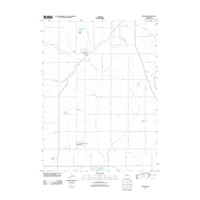
2011 Map of Kennard
USGS Topo · Published 2011About this map
Big Papillion Creek and its many tributaries, including Butter Flat Creek and the East Fork Big Papillion Creek, carve a dendritic drainage pattern across this agricultural landscape. The village of Kennard serves as a local hub, featuring the Kennard Post Office and nearby Kennard Cemetery. Further south, the settlement of Washington is anchored by the Washington Post Office. This map documents the complex water management systems of the region, from the Papillion Creek Reservoir W-4 and its associated Papillion Creek Dam W-4 to the southern reach of Newport Landing Lake. Family history is preserved in several burial grounds, such as the German Cemetery and Prairie View Cemetery, which are distributed among a rigid grid of county roads like Dutch Hall Rd and Pawnee Rd.
Find a feature on this map
54 named features on this map. Tap any name to fly to it.
Don’t see what you’re looking for? This feature index may not catch every label — zoom into the map to look around manually.
Map Details
Editions of this 2011 Kennard Map
This is the sole edition of this map. No revisions or reprints were ever made.
Other maps of this area

1893 · Fremont
USGS Topo · 1:125,000

1896 · Fremont
USGS Topo · 1:125,000

1955 · Fremont
USGS Topo · 1:250,000

1956 · Irvington
USGS Topo · 1:24,000

1957 · Fremont
USGS Topo · 1:250,000

1958 · Fremont
USGS Topo · 1:250,000

1968 · Valley
USGS Topo · 1:24,000

1968 · Kennard
USGS Topo · 1:24,000
1968 · Arlington
USGS Topo · 1:24,000
1968 · Fort Calhoun
USGS Topo · 1:24,000