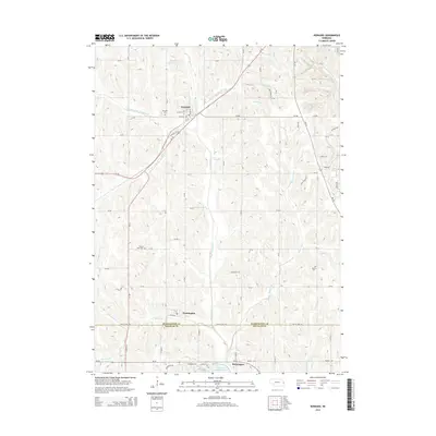
2014 Map of Kennard
USGS Topo · Published 2014About this map
Kennard and the smaller village of Washington anchor the agrarian landscape of the Nebraska plains as they appeared in 2014. The topography is defined by the branching network of Big Papillion Creek, with numerous named tributaries such as Hinz Fork, Leach Br, and Butter Flat Cr carving out the low-lying drainages. Genealogists will find several burial grounds noted, including Kennard Cem and Prairie View Cem in the north, and German Cem to the south. Further south, the map illustrates the residential development around Newport Landing Lake on the edge of Bennington, marking the transition from traditional farm tracts to contemporary suburban planning. This 2014 survey captures the precise boundary between Washington County and Douglas County, showing the enduring grid of section roads like CR-36 and highway arteries like Us-30 that facilitate movement through the river-bottom lands.
Find a feature on this map
67 named features on this map. Tap any name to fly to it.
Don’t see what you’re looking for? This feature index may not catch every label — zoom into the map to look around manually.
Map Details
Editions of this 2014 Kennard Map
This is the sole edition of this map. No revisions or reprints were ever made.
Other maps of this area

1893 · Fremont
USGS Topo · 1:125,000

1896 · Fremont
USGS Topo · 1:125,000

1955 · Fremont
USGS Topo · 1:250,000

1956 · Irvington
USGS Topo · 1:24,000

1957 · Fremont
USGS Topo · 1:250,000

1958 · Fremont
USGS Topo · 1:250,000

1968 · Valley
USGS Topo · 1:24,000

1968 · Kennard
USGS Topo · 1:24,000
1968 · Arlington
USGS Topo · 1:24,000
1968 · Fort Calhoun
USGS Topo · 1:24,000