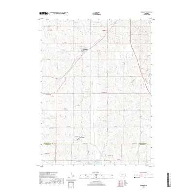
2017 Map of Kennard
USGS Topo · Published 2017About this map
Kennard sits at the northern end of this prairie landscape, where the local road network of Co Rd 30 and Co Rd P30 intersects the village center. The map reveals a high concentration of small watercourses and drainage branches that feed into the Big Papillion Cr system, including Falls Br, Boston Br, and Richter Br. This complex hydrology is managed through features like the Papillion Creek Reservoir W-4, illustrating the region's long-standing focus on water control and land use.
Find a feature on this map
53 named features on this map. Tap any name to fly to it.
Don’t see what you’re looking for? This feature index may not catch every label — zoom into the map to look around manually.
Map Details
Editions of this 2017 Kennard Map
This is the sole edition of this map. No revisions or reprints were ever made.
Other maps of this area

1893 · Fremont
USGS Topo · 1:125,000

1896 · Fremont
USGS Topo · 1:125,000

1955 · Fremont
USGS Topo · 1:250,000

1956 · Irvington
USGS Topo · 1:24,000

1957 · Fremont
USGS Topo · 1:250,000

1958 · Fremont
USGS Topo · 1:250,000

1968 · Valley
USGS Topo · 1:24,000

1968 · Kennard
USGS Topo · 1:24,000
1968 · Arlington
USGS Topo · 1:24,000
1968 · Fort Calhoun
USGS Topo · 1:24,000