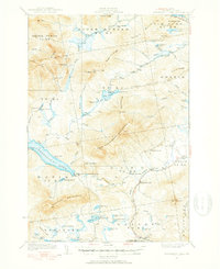
1932 Map of Kennebago Lake
USGS Topo · Published 1953About this map
The Arnold Trail winds through the northern reaches of this territory, following a historic path through the Franklin County highlands as documented in 1932. The landscape is defined by the massive presence of East Kennebago Mountain and Spotted Mountain, which frame a network of high-elevation lakes and working forests. The local economy of the early 1930s is visible in the scattered lumber camps, such as Camp No 10 and Camp No 11, and the industrial site at Langtown Mill near The Landing. Settlement is sparse and focused around established farms like Alder Stream Farm and Green Farm, while educational needs were met by the remote Kennebago Sch and Dallas Sch. The map preserves the complex drainage of the Dead River watershed, from the expansive Kennebago Lake to secluded bodies like Tim Pond and Loon Lake.
Find a feature on this map
88 named features on this map. Tap any name to fly to it.
Don’t see what you’re looking for? This feature index may not catch every label — zoom into the map to look around manually.
Map Details
Editions of this 1932 Kennebago Lake Map
4 editions found
Other maps of this area

1928 · Chain Lakes
USGS Topo · 1:48,000

1928 · Spencer
USGS Topo · 1:48,000

1928 · Stratton
USGS Topo · 1:48,000

1929 · Phillips
USGS Topo · 1:48,000

1931 · Cupsuptic
USGS Topo · 1:48,000

1932 · Phillips
USGS Topo · 1:62,500

1932 · Stratton
USGS Topo · 1:62,500

1932 · Kennebago Lake
USGS Topo · 1:48,000

1932 · Spencer
USGS Topo · 1:62,500

1932 · Arnold Pond
USGS Topo · 1:48,000