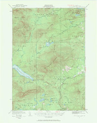
1932 Map of Kennebago Lake
USGS Topo · Published 1968About this map
Kennebago Lake and the surrounding wilderness of Franklin County dominate this 1932 topographic survey, revealing a landscape defined by logging camps and early twentieth-century industry. The map documents the active timber and agricultural presence in the region, noting established outposts like Langtown Mill, Alder Stream Farm, and Green Farm. These pockets of habitation are connected by the historic Arnold Trail, which follows the northern heights near Toenail Ridge and Boil Mtn.
Find a feature on this map
90 named features on this map. Tap any name to fly to it.
Don’t see what you’re looking for? This feature index may not catch every label — zoom into the map to look around manually.
Map Details
Editions of this 1932 Kennebago Lake Map
4 editions found
Other maps of this area

1928 · Chain Lakes
USGS Topo · 1:48,000

1928 · Spencer
USGS Topo · 1:48,000

1928 · Stratton
USGS Topo · 1:48,000

1929 · Phillips
USGS Topo · 1:48,000

1931 · Cupsuptic
USGS Topo · 1:48,000

1932 · Phillips
USGS Topo · 1:62,500

1932 · Stratton
USGS Topo · 1:62,500

1932 · Kennebago Lake
USGS Topo · 1:48,000

1932 · Spencer
USGS Topo · 1:62,500

1932 · Arnold Pond
USGS Topo · 1:48,000