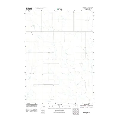
2012 Map of Kennebec SE
USGS Topo · Published 2012About this map
Kennebec Lake and the high plains of Lyman County define this landscape as it appeared in the early 21st century. This region of central South Dakota is characterized by a grid-like network of rural roads, including 319th Ave and 247th St, which partition the agricultural sections between drainages. The local hydrology is marked by the winding courses of Davis Cr in the southwest and Bad Cr in the southeast, both feeding into the larger prairie watershed. Further north, the presence of Jackson Lake and Kennebec Lake provides essential water resources in an area primarily dedicated to expansive ranching and farming operations. The map illustrates the persistent structure of the section-line road system that has organized this part of the Great Plains for generations.
Find a feature on this map
8 named features on this map. Tap any name to fly to it.
Don’t see what you’re looking for? This feature index may not catch every label — zoom into the map to look around manually.
Map Details
Editions of this 2012 Kennebec SE Map
This is the sole edition of this map. No revisions or reprints were ever made.
Other maps of this area

1951 · Ideal NW
USGS Topo · 1:24,000

1951 · Ideal NE
USGS Topo · 1:24,000

1952 · Reliance SW
USGS Topo · 1:24,000

1952 · Hamill NW
USGS Topo · 1:24,000

1955 · Mitchell
USGS Topo · 1:250,000

1959 · Mitchell
USGS Topo · 1:250,000
1978 · Brakke Dam
USGS Topo · 1:24,000
1978 · Lyman
USGS Topo · 1:24,000

1978 · Kennebec SW
USGS Topo · 1:24,000
1978 · Kennebec SE
USGS Topo · 1:24,000