
1951 Map of Ideal NE
USGS Topo · Published 1953About this map
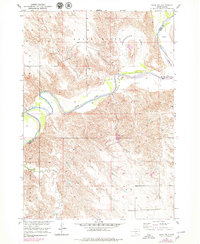
The White River carves a dramatic, winding path through this South Dakota landscape, defining the border between Lyman and Tripp counties. This 1951 field survey highlights the sharp meanders of the waterway, including the prominent Horseshoe Bend. The surrounding terrain transitions from the river's immediate breaks into the broad Lone Star Valley to the south. Settled life in this rural stretch of the Missouri River Basin centers on the Red Hill Ch and its accompanying Red Hill Cem, while education is anchored by the localized Houston Sch and Lone Star Sch. Drainage from the higher ground is carried by seasonal flows like Davis Creek and Old Lodge Creek, which cut through a landscape otherwise marked by scattered Gravel Pits and section-line roads typical of mid-century Great Plains agriculture.
Find a feature on this map
12 named features on this map. Tap any name to fly to it.
Don’t see what you’re looking for? This feature index may not catch every label — zoom into the map to look around manually.
Map Details
Editions of this 1951 Ideal NE Map
2 editions found
Other maps of this area

1951 · Ideal NW
USGS Topo · 1:24,000

1952 · Reliance SW
USGS Topo · 1:24,000

1952 · Hamill NW
USGS Topo · 1:24,000

1955 · Mitchell
USGS Topo · 1:250,000

1959 · Mitchell
USGS Topo · 1:250,000

1971 · Hamill
USGS Topo · 1:24,000

1978 · Kennebec SW
USGS Topo · 1:24,000
1978 · Kennebec SE
USGS Topo · 1:24,000

1982 · King Dam
USGS Topo · 1:25,000
1982 · Ideal
USGS Topo · 1:24,000