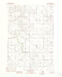
1982 Map of Ideal
USGS Topo · Published 1982About this map
Ideal sits at the heart of this Tripp County landscape, serving as a focal point for the surrounding rural sections during the late 1970s and early 1980s. The terrain is defined by the winding course of Dog Ear Creek, which carves a distinct path through the northern and southern portions of the map. To the north, Star Valley provides a geographic center for local education at the Star Valley Sch, a vital landmark for tracing family history in this corner of South Dakota. The presence of the Heller Landing Strip highlights the importance of small-scale aviation in connecting these remote agricultural communities. Smaller drainages like Owl Creek branch away from the primary waterway, while the township boundaries of Greenwood and Lone Tree provide the essential framework for researchers tracking land ownership and local governance in this sparsely populated prairie region.
Find a feature on this map
8 named features on this map. Tap any name to fly to it.
Don’t see what you’re looking for? This feature index may not catch every label — zoom into the map to look around manually.
Map Details
Editions of this 1982 Ideal Map
This is the sole edition of this map. No revisions or reprints were ever made.
Other maps of this area

1951 · Presho 4 NE
USGS Topo · 1:24,000

1951 · Ideal NW
USGS Topo · 1:24,000

1951 · Ideal NE
USGS Topo · 1:24,000

1955 · Martin
USGS Topo · 1:250,000

1955 · Mitchell
USGS Topo · 1:250,000

1958 · Martin
USGS Topo · 1:250,000

1959 · Mitchell
USGS Topo · 1:250,000

1982 · Presho 4 SE
USGS Topo · 1:25,000

1982 · King Dam
USGS Topo · 1:25,000

1982 · Winner North
USGS Topo · 1:25,000