
1982 Map of Presho 4 SE
USGS Topo · Published 1982About this map
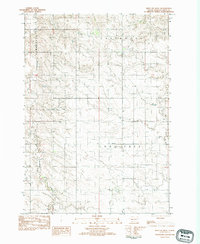
Lone Tree and Greenwood townships define this rural expanse in Tripp County, where the landscape is marked by the winding courses of Cottonwood Creek and Owl Creek. This 1982 survey captures the prairie character of South Dakota as it appeared in the late 1970s, documented shortly after aerial photography was completed in 1974. The map reveals a sparse network of section lines and unimproved roads connecting isolated landmarks like the Eden Sch and the Curlew boundary. Industrial activity is limited to scattered Gravel Pits and a smaller Gravel Pit, suggesting the primary local infrastructure needs of the era. The terrain is characterized by a high frequency of contour lines, illustrating the drainage patterns that feed into the local creek systems during this period of South Dakota's agricultural development.
Find a feature on this map
8 named features on this map. Tap any name to fly to it.
Don’t see what you’re looking for? This feature index may not catch every label — zoom into the map to look around manually.
Map Details
Editions of this 1982 Presho 4 SE Map
2 editions found
Other maps of this area

1951 · Presho 4 NE
USGS Topo · 1:24,000

1951 · Ideal NW
USGS Topo · 1:24,000

1951 · Presho 4 NW
USGS Topo · 1:24,000

1955 · Martin
USGS Topo · 1:250,000

1955 · Mitchell
USGS Topo · 1:250,000

1958 · Martin
USGS Topo · 1:250,000

1959 · Mitchell
USGS Topo · 1:250,000

1982 · Two Nation Creek
USGS Topo · 1:25,000

1982 · Witten
USGS Topo · 1:25,000
1982 · Miller Hill
USGS Topo · 1:25,000