
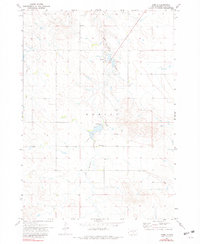
1971 Map of Hamill
USGS Topo · Published 1974About this map
Hamill sits as a small hub in the northern reaches of this territory within the Rosebud Indian Reservation during the early 1970s. The landscape is defined by the winding course of No Moccasin Creek, which dictates the placement of local infrastructure and water management, evidenced by the Spillway Elev 1800. A quiet network of section-line roads connects the small community to rural landmarks like the Center Moss Sch and a local Cem. The mapping reflects a period of established ranching and farming, noted by the extensive fencelines visible in the aerial photogrammetry used to produce this survey.
Find a feature on this map
7 named features on this map. Tap any name to fly to it.
Don’t see what you’re looking for? This feature index may not catch every label — zoom into the map to look around manually.
Map Details
Editions of this 1971 Hamill Map
2 editions found
Other maps of this area

1951 · Ideal NE
USGS Topo · 1:24,000

1952 · Hamill NW
USGS Topo · 1:24,000

1952 · Hamill NE
USGS Topo · 1:24,000

1955 · Mitchell
USGS Topo · 1:250,000

1959 · Mitchell
USGS Topo · 1:250,000

1971 · Hamill SE
USGS Topo · 1:24,000

1971 · Rattlesnake Butte East
USGS Topo · 1:24,000

1971 · Rattlesnake Butte West
USGS Topo · 1:24,000

1982 · King Dam
USGS Topo · 1:25,000

1982 · Winner North
USGS Topo · 1:25,000