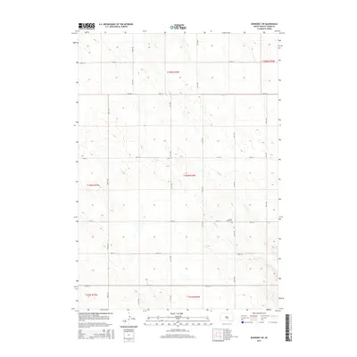
2015 Map of Kennebec SW
USGS Topo · Published 2015About this map
Davis Cr meanders across this rural expanse of Lyman County, defining the drainage patterns in a landscape structured by the Public Land Survey System. The map shows a precise grid of section lines and gravel roads, such as 244th St and 314th Ave, that delineate the agricultural parcels of the High Plains. A singular point of historical and genealogical interest is the Prairie View Cem, located near the intersection of 249th St and 313th Ave. This remote burial ground serves as a silent record of the families who settled this portion of South Dakota. The topography is characterized by subtle elevation changes and numerous small depressions, typical of the regional prairie potholes, which are captured in detail by the ten-foot contour intervals of this 2015 U.S. Geological Survey update.
Find a feature on this map
20 named features on this map. Tap any name to fly to it.
Don’t see what you’re looking for? This feature index may not catch every label — zoom into the map to look around manually.
Map Details
Editions of this 2015 Kennebec SW Map
This is the sole edition of this map. No revisions or reprints were ever made.
Other maps of this area

1951 · Presho 4 NE
USGS Topo · 1:24,000

1951 · Ideal NW
USGS Topo · 1:24,000

1951 · Ideal NE
USGS Topo · 1:24,000

1955 · Martin
USGS Topo · 1:250,000

1955 · Mitchell
USGS Topo · 1:250,000

1958 · Martin
USGS Topo · 1:250,000

1959 · Mitchell
USGS Topo · 1:250,000
1978 · Presho
USGS Topo · 1:24,000
1978 · Brakke Dam
USGS Topo · 1:24,000

1978 · Kennebec SW
USGS Topo · 1:24,000