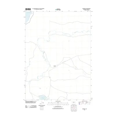
2011 Map of Kennedy
USGS Topo · Published 2011About this map
Gordon Creek meanders extensively through this portion of Cherry County, defining much of the drainage pattern in a landscape characterized by low-lying wetlands and scattered water bodies. The settlement of Kennedy serves as a central point of orientation, situated at the junction of several local routes including State Hwy Spur 16B. The geography is further punctuated by the northern reach of Merritt Reservoir and the isolated Lone Tree Lake to the south. This area, which includes the small cluster known as Tiny Town, reflects the sparsely populated ranching and grassland character typical of the Nebraska Sandhills. The network of unimproved roads and spurs highlights the remoteness of these outposts and their reliance on the creek systems for water management in an otherwise semi-arid region.
Find a feature on this map
6 named features on this map. Tap any name to fly to it.
Don’t see what you’re looking for? This feature index may not catch every label — zoom into the map to look around manually.
Map Details
Editions of this 2011 Kennedy Map
This is the sole edition of this map. No revisions or reprints were ever made.
Other maps of this area

1950 · Simeon
USGS Topo · 1:62,500

1950 · Kennedy
USGS Topo · 1:62,500

1951 · Bull Lake
USGS Topo · 1:62,500

1951 · Brownlee
USGS Topo · 1:62,500

1957 · Valentine
USGS Topo · 1:250,000

1959 · Valentine
USGS Topo · 1:250,000

1985 · Goose Creek
USGS Topo · 1:100,000
1985 · Windmill Lake
USGS Topo · 1:24,000

1985 · Valentine
USGS Topo · 1:100,000
1985 · Snake River Falls
USGS Topo · 1:24,000