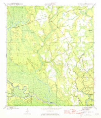
1945 Map of Kennedy Creek
USGS Topo · Published 1973About this map
The confluence of the Apalachicola River and the Chipola River anchor the southern reach of this 1940s landscape, where river landings and remote timber camps define the local geography. Significant portions of the Apalachicola National Forest dominate the central and eastern sections, interrupted by family-named landmarks like Hathcock Bay and Fields Bay. The presence of the Graveyard Pole Lookout suggests the critical importance of fire observation in this heavily wooded region during the mid-20th century.
Find a feature on this map
30 named features on this map. Tap any name to fly to it.
Don’t see what you’re looking for? This feature index may not catch every label — zoom into the map to look around manually.
Map Details
Editions of this 1945 Kennedy Creek Map
4 editions found
Other maps of this area

1944 · White City
USGS Topo · 1:24,000

1944 · Forbes Island
USGS Topo · 1:24,000

1945 · Dead Lake
USGS Topo · 1:31,680

1945 · Forbes Island
USGS Topo · 1:31,680

1945 · Kennedy Creek
USGS Topo · 1:31,680

1945 · White City
USGS Topo · 1:31,680

1945 · Orange
USGS Topo · 1:31,680

1945 · Wewahitchka
USGS Topo · 1:31,680

1945 · Fort Gadsden
USGS Topo · 1:31,680

1946 · Sumatra
USGS Topo · 1:31,680