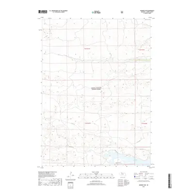
2017 Map of Kennedy NW
USGS Topo · Published 2017About this map
Samuel R McKelvie National Forest dominates this section of Cherry County, defining a landscape of rolling sandhills and remote grasslands. The southern portion of the sheet is shaped by the reach of the Merritt Reservoir, a significant water body providing a stark contrast to the surrounding arid terrain. Along the northern reaches, the seasonal flow of Steer Cr cuts through the plains, while the interior is navigated via a sparse network of forest roads and trails. Researchers will find the Powderhorn Trl and Powder Finger Trl winding through the sandhills, connecting to the primary artery of 16 F to 97 Rd. The map illustrates the specialized land management within the National Forest, where the absence of traditional townships highlights the preservation of this unique Nebraska ecosystem.
Find a feature on this map
11 named features on this map. Tap any name to fly to it.
Don’t see what you’re looking for? This feature index may not catch every label — zoom into the map to look around manually.
Map Details
Editions of this 2017 Kennedy NW Map
This is the sole edition of this map. No revisions or reprints were ever made.
Other maps of this area

1950 · Powderhorn Valley
USGS Topo · 1:62,500

1950 · Kennedy
USGS Topo · 1:62,500

1950 · Kilgore
USGS Topo · 1:62,500

1950 · Cody
USGS Topo · 1:62,500

1957 · Valentine
USGS Topo · 1:250,000

1959 · Valentine
USGS Topo · 1:250,000
1985 · Kilgore SE
USGS Topo · 1:24,000

1985 · Cooper Canyon
USGS Topo · 1:24,000
1985 · Cody SE
USGS Topo · 1:24,000

1985 · Cody
USGS Topo · 1:100,000